![]()
A recap of available maps & resources with a Ferndale Focus. If you have additions or corrections please contact us at: info@ferndalehistoricalsociety.org
SEE ALSO: HISTORY WANTED
LIBRARY OF MICHIGAN: The Library of Michigan provides powerful resources to Michigan residents for free! This includes access to normally paid resources like Newspapers.Com and some elements of Ancestry.Com. It also includes Sanborn maps, local and international newspapers, military records, and a treasure trove of searchable history! Here is a GUIDE to get you started.
SANBORN MAPS: Originally published by The Sanborn Map Company (Sanborn), the maps were created to allow fire insurance companies to assess their total liability in urbanized areas. They contain detailed information about properties and buildings which can be compared year over year when researching history. Click the guide above and scroll to the bottom of page 1 to start your research.
AERIAL MAPS: Oakland county maintains a fascinating set of aerial maps useful to compare changes over time. Be sure to visit their site HERE Note: they often change that web address, if the link no longer works, let us know and search their home page for Maps HERE
Another source of aerial maps to browse is HERE They claim to have rolls on non-indexed photos that you can browse through to discovers some gems. They even make a game of users identifying various locations. Good luck!
DTE AERIAL MAPS: Wayne State University hosts an interesting set of aerial maps provided by DTE. These range from 1949 up thru the 1990s for Oakland and other counties. The website and files can be tricky to access, but worth exploring! Click HERE
PLAT MAPS: A comprehensive land recording of the real estate or real property's dimensions, drawn to scale, showing the divisions. Usually show subdivisions broken into blocks with streets and alleys. Further refinement often splits blocks into individual lots, usually for the purpose of selling the described lots; this has become known as "subdivision". The Museum has some Plat Maps on file. A wonderful online version is HERE
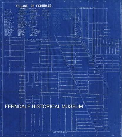
STREET NAMES: On March 18, 1920 dozens of streets in Ferndale were renamed to reduce mailing confusion with other communities. For example Plum Street became East Cambourne and Woodle Street became West Saratoga. A few street names were also changed in later years. This can create confusion when tracking down area history. Fortunately the museum has a list of street name changes, plus a curious "blueprint map" created just before the name change, to help solve mysteries!
LIBRARY OF CONGRESS: You may have noticed many maps are from the Library of Congress (LOC). They have a well organized collection which is fun to explore starting HERE
ZILLOW MAPS: Used primarily for real estate transactions, Zillow does provide current maps and property detail HERE
GOOGLE MAPS: A fantastic source of current maps and images of current
properties is HERE There is also Google Earth which often contains
satellite views from prior years HERE
CITY RECORDS:
Although not a "map", the city website offers extensive details about
a specific address. Start HERE by entering a street (or specific address)
then click to view building permits, utilities, legal description, etc.
City Council Minutes are also a valuable source of information about a
specific address. They are available HERE
MAPS AS ART: Maps are popular "art" for sale on Etsy and other sites. A Ferndale example is HERE
NEWSPAPERS: Historic newspapers are a fascinating glimpse into history. They are easy to search for a specific address. The Royal Oak Tribune, Free Press, Detroit News and so many more are available free to Michigan residents via the Library of Michigan (see above). The museum has nearly all Ferndale Gazette issues as searchable PDFs from the museum (not online). To learn more about the Gazette click HERE.
U.S. CENSUS RECORDS: These offer an interesting history of who lived in your home. It can sometimes be tedious to find specific info and hard to read old hand-written records, but usually worth the search! Data are delayed 72 years to protect living individuals. These are available in the museum, and many places online (Ancestry.com and official Census site HERE). Extensive family history, and census records, are available for free at the Church of Latter-day Saints website HERE.
HISTORY OF YOUR HOME: Ideas and resources to research your home are HERE
|

Unauthorized use or duplication of this material without expressed
and written consent from the Ferndale Historical Society is prohibited.
Revised: Jan 14, 2025
